OFFERING
Services to leverage Earth Observation and auxiliary
datasets, along with advanced online processing
methods, to enhance agricultural monitoring activities.
THE FOOD SECURITY EXPLORER OFFERS VARIOUS FEATURES
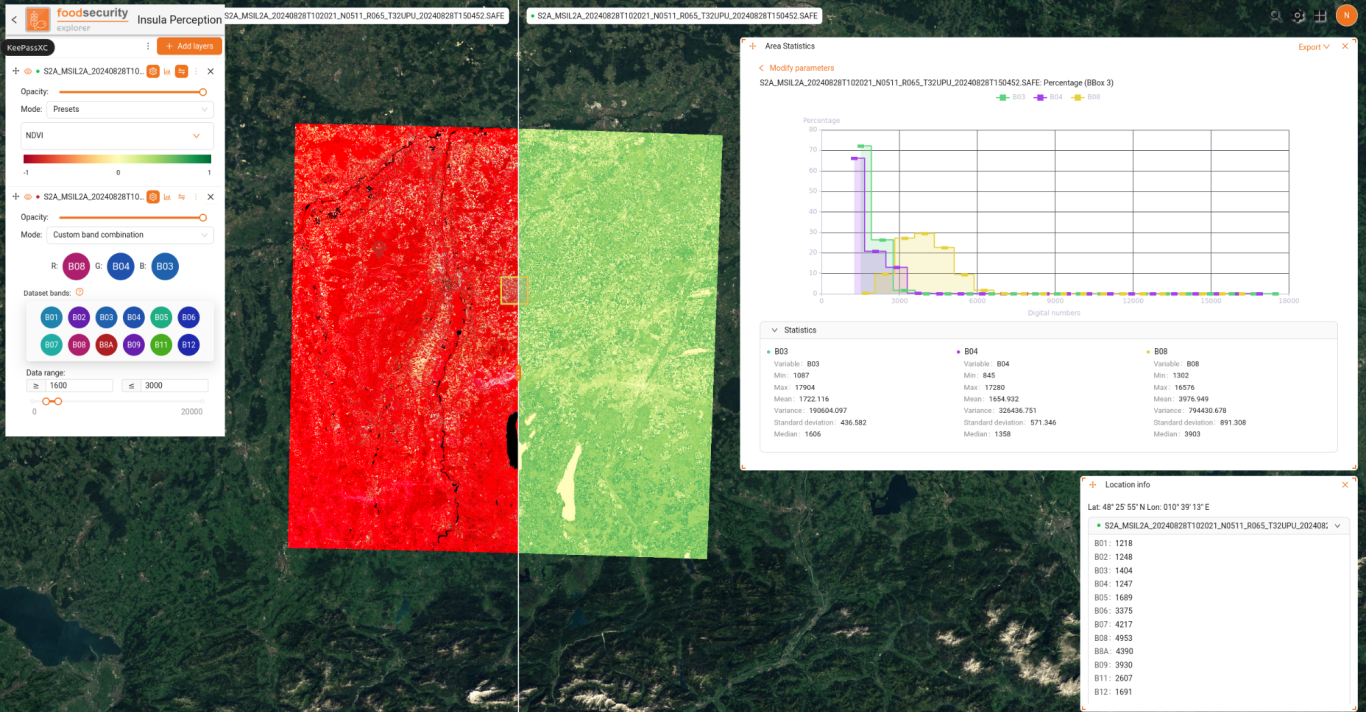
PERCEPTION: a data analytics and management component,
which is used to perform data discovery and analytics.

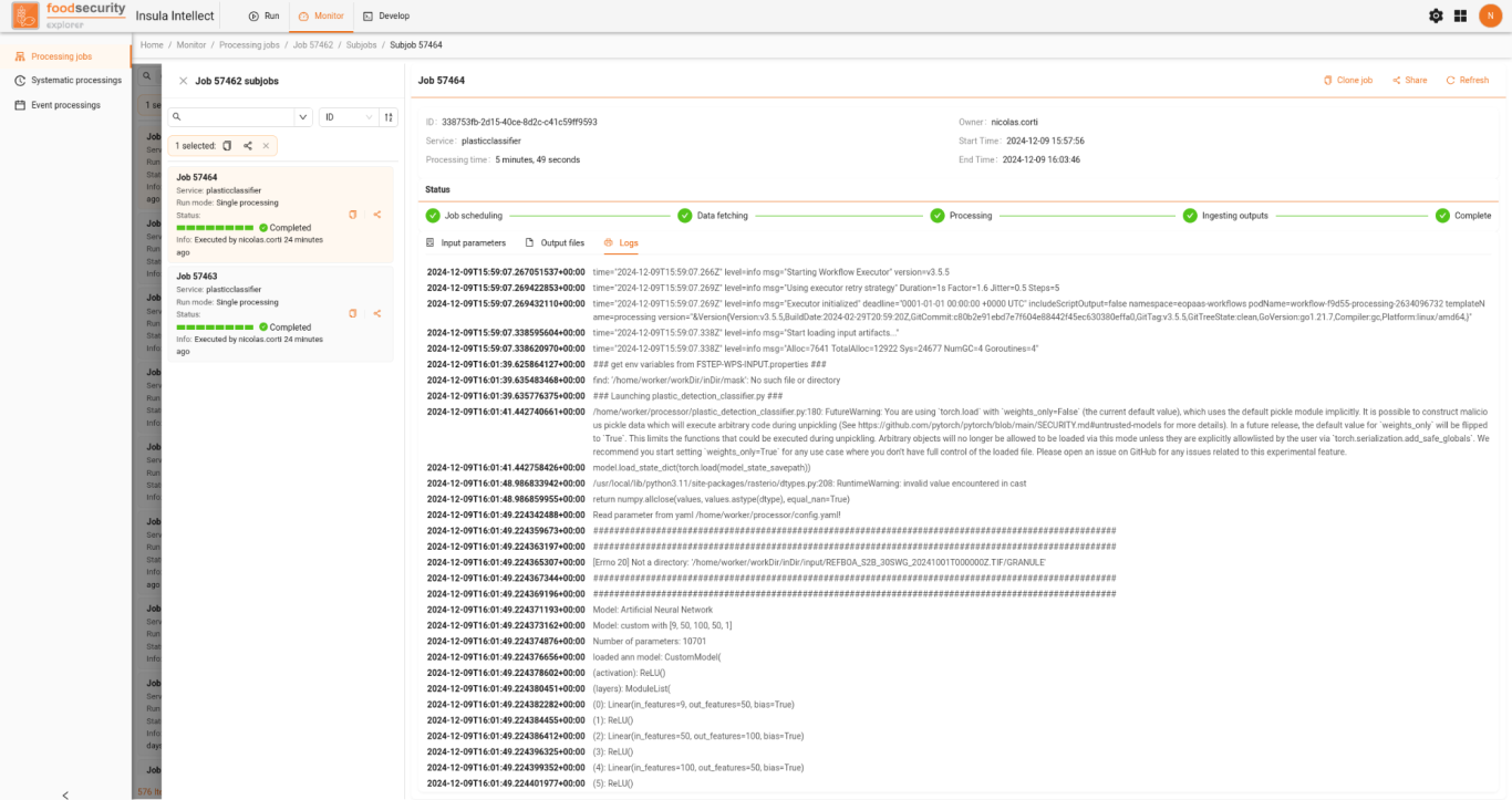
INTELLECT: a service runner interface, which is used to exploit the processing engine for different type of
processing modes:
Standard: inputs data are chosen at run time.
Processing campaign: supporting bulk processing.
Event driven: to trigger processing services automatically upon occurrence of a specific event.


CODE: a (jupyter hub) component, that allows multiple users to access and work with Jupyter Notebooks in a shared, scalable, and secure environment for data exploration and service prototyping.
.

AWARENESS: a component, where you can manage, controll access permissions
and shared all your data with other users.
Thematic Processing Services
ALGORITHM
DESCRIPTION
EO-Composites
Seamless cloud free band composites using max pixel values of Soil Adjusted Vegetation Index for a single season.
EO-Mangrove
Presence/absence mangrove maps using a Random Forest
algorithm and Sentinel-2 max SAVI composites. The predictions are made using a previously trained model using
polygon shapefile depiction mangrove presence in Tanzania and derived circa 2010.
Sen2AgriL2A
Sen2Agri MAJA L2A service to apply Atmospheric Correcton to Sentinel-2 L1C data. This processing step is a prerequisite for all other Sen2Agri modules.
Sen2AgriL3A (v1.0)
Sen2Agri Cloud-free service uses multiple Sentinel-2 L2A images (generated using Sen2Agri L2A service) to generate a cloud-free temporal stack (syntheses) of surface
reflectance values.
Sen2AgriL3B (v1.0)
Sen2Agri Leaf Area service generate a LAI product from Sentinel-2 L2A products (generated using Sen2Agri L2A service). LAI is a commonly used biophysical parameter that characterises the plant canopy.
Sen2AgriL4A (v1.0)
Sen2Agri Cropland Mask service creates a Cropland mask, which is a binary mask separating annual cropland areas and other areas at 10m spatial resolution. Masks are generated throughout the agricultural season incorporating additional Sentinel-2 images.
Sen2AgriL4B (v1.0)
This Sen2Agri service creates a crop type map based on Sentinel-2 images (previously generated using Sen2Agri L2A
service) and user-provided in situ data. Two maps are created; the first in the middle of the season and the second at the end of the season.
Sentinel-2 Red Edge Position Index
S2REP (The Sentinel-2 Red-Edge Position Index): Red edge, as the infliction point of the strong red absorption to near infrared reflectance, includes the information of both crop (chlorophyll content) N and growth status.
Sentinel-2 Brightness Index
Brightness Index for Sentinel-2: The BI is sensitive to the
brightness of soils which is highly correlated with the humidity and the presence of salts in the surface.
Sentinel-2 Ratio Index
The default is to use Sentinel-2 Band 8 (Near Infrared) as Band_A and Band 4 (Red) as Band_B. The default band values belong to the Ratio Vegetation Index (RVI). Set the bands as needed.
Sentinel-2 Normalized Band Difference Index
The default is to use Sentinel-2 Band 8 (Near Infrared) as Band_A and Band 4 (RED) as Band_B. The default band values belong to the Normalized Difference Vegetation Index (NDVI). Set the bands as needed.
Sentinel-2 Normalized Difference Water
Index
The Normalized Difference Vegetation Index NDWI is sensitive to changes in liquid water content of vegetation canopies.
Sentinel-2 Modified Chlorophyll Absorption
Ratio Index
Sentinel-2 MCARI is responsive to leaf chlorophyll
concentrations and ground reflectance.
VISTA Green Crop Leaf Area Service
Leaf Area Index (LAI) measures the amount of leaf material in an ecosystem, which imposes important controls on photosynthesis, respiration, rain interception, and other processes that link vegetation to climate.
BioparProcessor
Processor for generation of bio-physical parameters from
Sentinel2.
Sentinel-1 Level-2 Backscatter Service
This parallel processing service creates Sentinel-1 Level-2
Backscatter Amplitude from GRD inputs.
Sentinel-1 SLC Coherence Service
This parallel processing service creates Sentinel-1 Level-2
Coherence from 2 SLC inputs.
MAJA Atmospheric Correction
Sentinel-2 Atmospheric Correction from L1C to L2A using MAJA v3.2.
VISTA Sentinel-2 Reflectance at Bottom of
Atmosphere
VISTA GmbH is providing this Sentinel-2 Reflectance at Bottom of Atmosphere service based on radiative transfer moelling (SLC). This public processor is currently deployed, meanwhile please contact support@foodsecurity-explorer.com
ActiveFire
Active fire detection.
CropCalendar
Harvest detection: checking from space which fields are ready to be harvested.
Supporting Processing Services
Crop_Map_Generator
Creates a crop map based on a h5 file output from inference
model.
ALGORITHM
DESCRIPTION
Crops input GTIF to cutline shape
Crops any GTiff to a shape file from the Reference data
collection, if provided as .zip with the same name.
Prepare_Monthly_Composites
This service takes monthly composite TIF files as input and
outputs them as H5 files.
Create_Monthly_Composites
From several REFBOA and LAI files, it creates 12 monthly
composites. It needs a databasket with all REFBOA and LAI files, a collection id (default collection is set to EE_S2_COMPOSITES), a UTM tile name and a season start year.
GUI Applications
ALGORITHM
DESCRIPTION
ECOSTRESSDataDownload
This service prepares precalculated EEH products for download.
Jupyter Hub
jupyter interactive development interface.
Orfeo Toolbox Monteverdi in QGIS
The Monteverdi Image Processing Graphical User
Application (GUI).
QGIS Desktop Application
Quantum GIS - A GUI Geographical Information Package.
ENMAP Toolbox in QGIS
Start ENMAP Toolbox in QGIS.
ESA SNAP Desktop Application
The Sentinel Applications Platform v5.0 - A Graphical User
Application.
Wir benötigen Ihre Zustimmung zum Laden der Übersetzungen
Wir nutzen einen Drittanbieter-Service, um den Inhalt der Website zu übersetzen, der möglicherweise Daten über Ihre Aktivitäten sammelt. Bitte überprüfen Sie die Details in der Datenschutzerklärung und akzeptieren Sie den Dienst, um die Übersetzungen zu sehen.
